Travel Info
How to get to SJC from São Paulo International Airport (Guarulhos)
By Car
We suggest using a GPS car application (eg Waze) to get to the Presidente Dutra Highway (São Paulo-Rio de Janeiro Highway) or to the Ayrton Senna Highway (Workers' Highway).* The airport offers Uber service
By Bus - Company Pássaro Marrom
Phone numbers: (011) 6445-2505, 6445-3783 and 6445-3811(012) 3921-9892
Website: www.passaromarron.com.br
Travel by taxi, Uber or metro to the Tietê Bus Terminal. The Pássaro Marron booth is located on the second floor of the Terminal.
Hours: from 5:30 in the morning, with departure intervals every 20 minutes and hourly starting at 9:00 p.m.
Last departure at 23h59.
Prices vary between R$ 30.20 and R$ 42.34, depending on the departure time.
By Taxi - Special Taxis
Location: consult the airport taxi serviceEstimated price: consult the airport taxi service
View the road maps
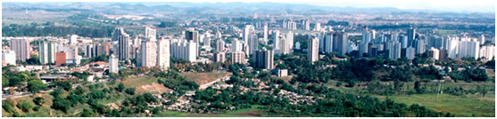
São José dos Campos
São José dos Campos - Banhado
With an estimated population of almost 700.000, São José dos Campos (SJC) is presently the 4th largest city in the state of São Paulo, and the largest and most important in the Paraíba Valley. Its area was first occupied in 1590 by a cattle farm, where today is the borderline between SJC and Jacarei cities. It received the status of town in April 22, 1864 and received its present name in 1871.
SJC is one of the largest industrial and technological centers of the country and the home of well known research centers, such as the Instituto Nacional de Pesquisas Espaciais (INPE), the Comando-Geral de Tecnologia Aeroespacial (DCTA), the Instituto Tecnológico da Aeronáutica (ITA), the Universidade do Vale do Paraíba (UNIVAP), and the Universidade Estadual Paulista "Julio de Mesquita Filho" (UNESP). São José dos Campos is also the home of EMBRAER (Empresa Brasileira de Aeronáutica), the 3rd largest aircraft company in the world, the largest and second oldest GM (General Motors) plant in Brazil, started 1958, and many other technological and electronics industries, totaling more than 700 companies.
Due to its privileged geographical position, between the mountain chains of Mantiqueira and Serra do Mar, SJC is very close to excellent leisure opportunities at the beach or up in the mountains. It is located between the metropolitan areas of Rio de Janeiro (330 km North), in Rio de Janeiro state, and São Paulo (80 km South), the two largest Brazilian cities.